
See the updated page at: https://sheltercovehouse.com/things-to-do/
Events: See Visit Lost Coast – Events
Activities
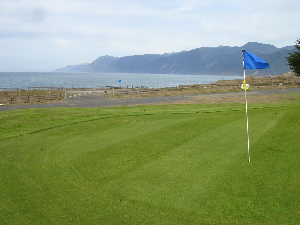
Shelter Cove Golf
The Golf Course is directly across the street from the Shelter Cove House on Sea View, and it running alongside the airstrip and overlooking Pacific Ocean. It is a nine hole links course covering 2,380 yards with a par of 33 for the men and 34 for the ladies. There is one par-5, four par-4s, and four par-3s. The slope rating is 110.
This is a nine hole links course covering 2,428 yards with a par of 33 for the men and 34 for the ladies. There is one par-5, four par-4s, and four par-3s. The slope rating is 103.
Greens fees are payable using the pay kiosk at hole #1: $15.00 – 9 holes, $20 – 18 holes, $50 – 1 week, $90 – 1 month. Annual greens fees available from the District office during business hours Monday through Friday 8AM – 4PM: $500 beginning July 1st and pro-rated throughout the year.
Shelter Cove Golf Course is a member of the Northern California Golf Association. NCGA has installed a computer in the club house for its members to register scores and calculate handicaps. The men’s league play on Saturdays at 10:00 and the ladies tee off on Wednesdays 10:00.
The Community Clubhouse Recreation Facility includes Abalone Hall, a 1200 sq ft rentable venue, a sports lawn for volleyball and croquet, bocce ball court and two horseshoe pits. Sports equipment (horseshoes, bocce balls, volleyballs and a croquet set are provided by the District.
Shelter Cove Hiking and Walking
There are lots of beautiful sites to see walking in and around Shelter Cove including watching the crashing waves and sunsets at the often empty Black Sands Beach. If you’re up for more adventure, hiking on the lost coast is a favorite among hikers. The coast to the north of Shelter Cove provides a great place to hike, as a day trip or a more prolonged endeavor. Parallel to this stretch of beach known by the locals as “Big Black Sands Beach” are mostly public lands managed by the Bureau of Land Management.
For a comprehensive Hiking Guide see: Guide to Hiking the Lost Coast Trail
Note, that page also has shorter trails around Shelter Cove.
See also BLM’s King Range Topography Map:

The beach is may be difficult to walk on at times since it is composed of a round sand and each step sinks in at the heel giving a weighed step. But by slowing the pace and/or taking advantage of trails that lift you up onto the bluffs you can make time and preserve energy. There are trails that take off from the beach and lead you along the creeks and streams or up into the mountains and back into the wild public lands that surround Shelter Cove.
Wine Tasting / Wine Making

Briceland Vineyards is on the road between Redway and Shelter Cove
“Our wines are expressive of site, vintage and our hand-made small lot wine-making style. We are more than pleased to share our story, our experience of each vintage and info about our favorite vineyards, but the wine speaks for itself.”
Open Summer Weekends Sat & Sun 1-5 and all year by appointment. Contact us at: andrew@bricelandvineyards.com or (707) 923-2429.
Shelter Cove Beaches
Shelter Cove Mountain Biking
Paradise Royale is a relatively new 14-mile single-track loop on California’s Lost Coast in the King Range National Conservation Area.

Surfing Shelter Cove
As the cove is crescent-shaped, it can be triple-overhead off Point Delgada but chest-high near the boat ramp.
Deadman’s is the most popular surf spot in Shelter Cove; the wave is a bit like Lower Trestles. Third Reef lies smack-dab between Deadman’s and No Pass, requiring a larger swell and a low tide to work properly. Long rights and lefts, with the rights usually being a tad slower than the left. Just south of that is No Pass, an excellent lefthander peeling along a horseshoe reef, providing smackable lips and some unreal speed sections. You won’t be disappointed.
Further south, requiring a brief paddle around Point No Pass and a walk down the beach, is the celebrated Gale Point, a rocky righthand point-break of much repute. Long, fast walls and sweet tube sections with the correct swell angle. Northwest pulses up to double-overhead with a high tide works best here.
- Shelter Cove Surfing
- Shelter Cove Surf Report & Forecast
- Lost Coast Surf Shack
- Hip Camp: Surfing the Lost Coast

Some of the Drowning Incidents in Shelter Cove, CA
- May 29, 2022 One Fatality, One Rescued – Water Rescue in Shelter Cove
- Woman swept out to sea in Northern California
- Search Called Off for 2 Who Tried to Save Drowning Woman
- Drowning in Shelter Cove
- Drowning at Shelter Cove
- Shelter Cove Sign Campaign Aims to Stop Drownings on Black Sands Beach
California Parks and Recreation – Ocean Safety
Sport Fishing Shelter Cove
Shelter Cove is one of California’s premiere ocean fishing destinations. Sport fishing enthusiasts come for the salmon, which come close to the shore here May through August. Anglers can also catch an abundance of ling cod, rock cod, halibut, albacore and surf perch, and can fish from the shore for perch or rock fish. Fishermen can also launch a boat from the cove, which Point Delgada protects from the northwesterly winds.
Visitors can buy fishing licenses at Shelter Cove stores or charter a boat from a sport fishing business for a guided angling adventure. On calm days, abalone diving is also an option.
- Times Standard: Fishing the North Coast: Shelter Cove salmon starting to show
- Oregon Fish Reports: Solid salmon action at Shelter Cove
- Nor Cal Fish Reports: Shelter Cove
- Sea Hawk Sport Fishing Shelter Cove (707) 223-1600
- Captain Morris’ C’Mon Sport Fishing (707) 223-2362
- Outcast Sport Fishing (707) 223-0368
- Shelter Cove Fishing Preservation Inc.
- Shelter Cove Black Sands Fishing Trip 2019
- Captain Jake Mitchell of Sea Hawk Sport Fishing out of Shelter Cove targeted tuna on Sunday and Monday and did well both days. Shelter Cove, Fort Bragg boats whack the tuna – The warm tuna water came within reach of the two ports to our south – Shelter Cove and Fort Bragg – and anglers jumped at the chance to put the season’s first albies on board.

Sea Kayaking Shelter Cove
Dramatic vistas of steep cliffs plunging to the sea from a 2,000-foot ridgeline make the Lost Coast among the most scenic paddling areas on the West Coast. Here Cap Mendocino — the westernmost point of land in the “Lower 48”—plows into the Pacific, awash in sea spray, like the bow of a giant ship.
In the 40-mile lee of this massive cape are a handful of remote beaches where, under the right conditions, a skilled and adventurous paddler might make landfall. Although intermediate kayakers with good sea sense may enjoy short trips in the vicinity of Shelter Cove or Bear Harbor, the rest of this route can challenge even the most advanced coastal paddlers. The rewards, however, are great, as this remains the wildest stretch of seashore in the state. The North Coast’s natural beauty is widely celebrated, but far from fully grasped. Cruising along under paddle power is a unique opportunity.
Excerpted from Guide to Sea Kayaking Central and Northern California, by Roger Schumann owner/operator of Eskape Sea Kayaking School in Santa Cruz, CA. And as found at Inn of the Lost Coast
NOAA: Annual Prediction Tide Tables for SHELTER COVE, CA (9418024)
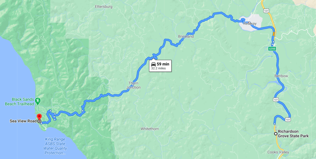
Avenue of the Giants
When you drive up to highway 101 from Shelter Cove and head north towards Eurika, you soon come upon the South Entrance of the Avenue of the Giants. The Avenue of the Giants runs parallel to 101 and there are many opportunities to switch from 101 to the Avenue between the north and south entrances. About halfway is the small town of Miranda which has a great market where the former owner of the Shelter Cove House on Sea View can sometimes be found among his prized antique cars.

“Avenue of the Giants – A Destination Vacation: Is a travel brochure featuring the world-famous scenic drive, which is a 31-mile portion of old Highway 101, that parallels Freeway 101 with its 51,222 acres of redwood groves. It is by far the most outstanding display of these giant trees in the entire 500-mile redwood belt and is accessible to all with convenient services provided along the way. The Avenue of the Giants is surrounded by the Humboldt Redwoods State Park which has the largest remaining stand of virgin redwoods in the world. Take time to browse tourist attractions in Humboldt County, CA, picnic, camp, hike, swim, fish, raft, or bike ride in the cool hush of these ancient redwood forests. Don’t miss visiting ROCKEFELLER FOREST, where 10,000 acres of indescribable beauty will surely awe any visitor. There are many trails in this forest, as well as, the 8th, 6th, 4th, and 2nd tallest trees, and the “Champion Coast Redwood” at 370 feet tall! SCOTIA is one of the last “company-owned” towns in California.”
Humboldt Redwoods State Park

Humboldt Redwoods State Park is a state park of California, United States, containing Rockefeller Forest, the world’s largest remaining contiguous old-growth forest of coast redwoods. It is located 30 miles (48 km) south of Eureka, California, near Weott in southern Humboldt County, within Northern California, named after the great nineteenth-century scientist, Alexander von Humboldt. The park was established by the Save the Redwoods League in 1921 largely from lands purchased from the Pacific Lumber Company. Beginning with the dedication of the Raynal Bolling Memorial Grove, it has grown to become the third-largest park in the California State Park system, now containing 51,651 acres (20,902 ha) through acquisitions and gifts to the state.[1]
From Wikipedia, the free encyclopedia
Richardson Grove State Park
Richardson Grove is a small park with giant redwoods by the Eel River. Driving north on 101 towards Shelter Grove, you pass right through Richardson Grove. It’s a great place to go from Shelter Cove or a nice stop on the way up or back.

Shelter Cove Airport
Shelter Cove offers a 3,400 foot runway for light, prop and turbo-prop aircraft. There is no fuel but Little River has 100LL about 45 miles south and Ukiah has 100LL. There are several fields to visit between Santa Rosa and Shelter Cove.
- AirNav.com | Shelter Cove Airport 0Q5
- Landing at Shelter Cove ~ 0Q5
- Wikipedia: Shelter Cove Airport
- Shelter Cove Airport Association
- Live Webcams at Shelter Cove Airport
- Marc’s Public Blog – Flying – 2008/07/04 Flight from Palo Alto to foggy Shelter Cove and back


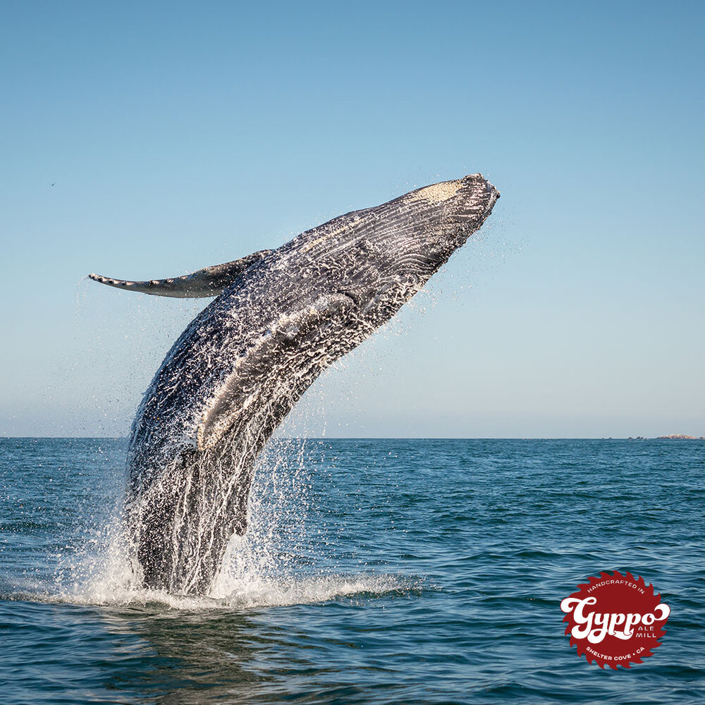
Whale Watching
Shelter Cove is a great place for seasonal whale watchers hoping to see grey, humped-back and killer whales. The abundant food supply make this portion of northern California’s coastline a one to two week critical stopping location for the grey whales during their migration and birthing periods.
Peak season in Shelter Cove is in April and May during the grey whale’s migration down the Pacific Coast to warmer waters.

WildLand Trekking – Lost Coast Trek
“The Lost Coast trail is one of the finest beach backpacking trips in the world – don’t miss this one of a kind tour!”

Lost Coast Adventure Tours
Magical redwoods inspire people from all over the world to visit this stunning location. Whether people find their way to this area through whispers of secret waterfalls and hidden swimming holes, or to check an item off their bucket, we are no doubt, the number one backpacking destination in Northern California.
Let us take you off the beaten path and into the heart of our world-renowned destination. We’ll handle the logistics, plan for the tides and show you the ropes.

Various Other Blogs and Blog Posts about Shelter Cove and/or the Lost Coast
- Lost Coast Trails – The Lost Coast trail is the premier coastal backpacking trail in California and because of its significance has been designated a National Recreation Trail. The experience of hiking where the land meets the sea is unforgettable and strenuous. This is the California Coastal Trail at its finest!
- Lost Coast Ranger – Lost Coast Trail and the King Range Wilderness – These are the personal thoughts of the King Range Wilderness Ranger. The purpose of this site is to get information to you, the potential visitor, so you can better plan your trip. The views and opinions expressed here do not represent the views or official positions of the BLM or the Department of the Interior
- Backpacker’s Review – Lost Coast Trail – King Range Wilderness (25-Mile Point-to-Point) – This ~25 mile route offers a rare coastal wilderness experience where you travel along a beach and must keep track of the tides! The route explores one of the most undeveloped stretches of shoreline in California. Along the way, you hike on the beach, travel over grassy bluffs, and dodge sea lions and ocean waves. +/- 1,000 feet of elevation over the course of this trek with a peak elevation of only ~150 feet. Highlights include coastal views as far as the eye can see, remote beaches, and a variety of wildlife including sea lions, seals, deer, and whales. The majority of the images here are from a trip in mid May. Unless otherwise noted all photos were taken by Richard O’Neill and are reused with permission.
- Endless Mountains Experience Hiking, Backpacking, Paddling, Camping, and Exploring: Lost Coast Trail and Northern California – I recently returned from a trip to the Lost Coast Trail and northern California. I went with my friend Mike who had long wanted to hike the Lost Coast Trail, and with no real vacation plans of my own, I decided to join.
- Backpacking the Lost Coast Trail – Everything you Need to Know – The Lost Coast Trail is one of my favorite thru-hikes and one of the best on the California coast. Quintessential Northern California coastal experience – tall cliffs, giant redwoods, moody fog, and abundant wildlife.
- MilkyWayPicnic – The Lost Coast – Our first camping trip of the year back in May had us feeling like we accidentally stumbled upon a real life fairyland. We didn’t think our trip to an isolated and wild section of the California coast was just in time for the lupines to be in their prime. Not just lupines but foxgloves and blackberries and even some wild strawberries. Our hikes were filled with delighted shouts when we come upon another lovely view which is every five minutes and all our fingers are stained purple from picking and eating blackberries all along the way.
- WhereverGoing’s Blog – The Lost Coast – Starting in the park, the Mattole Road heads west through the beautiful Redwoods along Bull Creek, then outside the park slowly winds its way up and over a mountain ridge, down to a picturesque valley filled with small farms and quiet villages, up and over another ridge, and will eventually skirt the Pacific a bit before winding though more mountains and ridges to Ferndale, a long three hour scenic drive to reach what takes about 40 minutes on 101.
- TroyOnTheRun – Follow My Journey While I Explore My Boundaries – Lost Coast Unsupported FKT – Running the Lost Coast in a single push Muse of all Muses, when a bucket list adventure route becomes an 11-month obsession.
See the Elk (?)

Close to Shelter Cove, CA is a meadow called “hidden valley” (by Needle Rock in Sinkyone Wilderness State Park). There are elk that migrate in and out of the area. This Bull and others were observed by the late Dan Thomas, who furnished this picture, taken mid December 2000.
See also Facebook: Things to do in Shelter Cove California
Other Lost Coast pages on Facebook
Facebook pages for Shelter Cove businesses
